 Back in April, we used
Giorgio’s business trip to Munich, Germany as an ideal excuse for some European sight-seeing
adventures.
Back in April, we used
Giorgio’s business trip to Munich, Germany as an ideal excuse for some European sight-seeing
adventures.
Giorgio had previously visited
Berlin, making Stephanie worried that we would be repeating much of his prior
visit. Those worries only increased when
she laid out a proposed itinerary for our visit and he claimed that he had
already visited all of the listed sites.
It turns out, however, that without Steph to plan the trip, he had
actually missed many of the highlights and we had a wonderful time exploring
a new city together.
Our visit to Berlin was
essentially a greatest hits tour of the metropolis. We wandered through the city to take in its
sites, occasionally stopping for a currywurst or German beer. We also made sure to make plenty of stops for
wiener schnitzel (although we do realize it’s a traditionally Austrian dish).


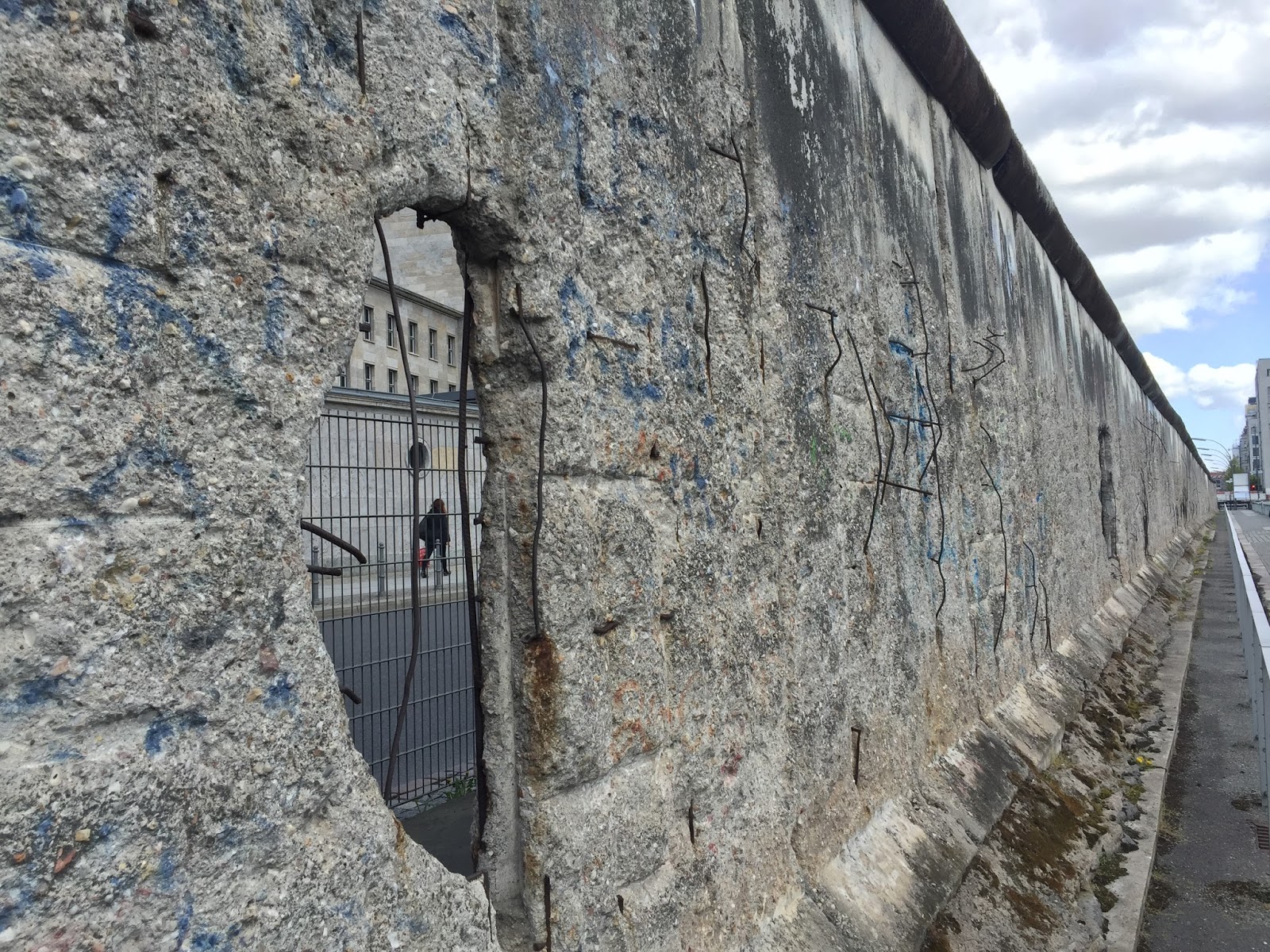
A visit to Berlin is a bit like taking a walking history class, with constant reminders of WWII and the Cold War - whether you’re looking at a fragment of the Berlin Wall...

...stopping in front of Brandenberg Gate...


..or pretending to cross from West to East Berlin at Checkpoint Charlie.


On a lighter note, we also made sure to hit some of the sites we had seen on the most recent season of Homeland, such as Potsdamer Platz where Steph pretended to be Carrie waiting to meet Saul...

The city has definitely evolved since the fall of the wall in 1989. There is construction going on everywhere and almost all of the portions of the wall have long since been removed or transported to another part of the city for exhibition.


For some reason, Steph had the erroneous idea that much of the wall would still be standing and/or that the delineation between East and West Berlin would still be obvious.
 That, however, is not the case – Germans
seem to have taken unification very seriously, eliminating many of the most
obvious reminders of the city’s decades-long division. Even the ampelmännchen or the "little traffic light men" (the famous East Berlin pedestrian traffic signs) can now be found throughout the unified city. Berlin also seems to be changing at a rapid
pace; Giorgio remarked that he barely recognized the city he remembered from his visit only ten years earlier. Maybe he didn't actually miss the "greatest hits" last time, but the city has changed so much the list itself has changed.
That, however, is not the case – Germans
seem to have taken unification very seriously, eliminating many of the most
obvious reminders of the city’s decades-long division. Even the ampelmännchen or the "little traffic light men" (the famous East Berlin pedestrian traffic signs) can now be found throughout the unified city. Berlin also seems to be changing at a rapid
pace; Giorgio remarked that he barely recognized the city he remembered from his visit only ten years earlier. Maybe he didn't actually miss the "greatest hits" last time, but the city has changed so much the list itself has changed. Berlin is home to a plethora of museums showcasing different eras of its history, making it impossible to visit everything in a short period of time. Regardless, we definitely recommend a visit to at least a few of the key sites, starting with the Museumsinsel, or Museum Island. In April, the island was mired in construction, making it difficult to appreciate the beautiful architecture and location of the five world-class museums housed on the island. Regardless, we still visited the famous bust of Nefertiti, the perhaps
less famous (but more interesting?) “golden hat,” and most of the contents of
the Pergamon Museum, other than the Pergamon temple itself. The Pergamon temple, originally transported
from what is now Turkey, is meant to be breathtaking, but that portion of the
museum is currently closed. That doesn’t
stop the German government from charging the full entry fee to the museum,
though, and apparently isn’t noteworthy enough to note upon purchase of a
ticket.
Berlin is home to a plethora of museums showcasing different eras of its history, making it impossible to visit everything in a short period of time. Regardless, we definitely recommend a visit to at least a few of the key sites, starting with the Museumsinsel, or Museum Island. In April, the island was mired in construction, making it difficult to appreciate the beautiful architecture and location of the five world-class museums housed on the island. Regardless, we still visited the famous bust of Nefertiti, the perhaps
less famous (but more interesting?) “golden hat,” and most of the contents of
the Pergamon Museum, other than the Pergamon temple itself. The Pergamon temple, originally transported
from what is now Turkey, is meant to be breathtaking, but that portion of the
museum is currently closed. That doesn’t
stop the German government from charging the full entry fee to the museum,
though, and apparently isn’t noteworthy enough to note upon purchase of a
ticket.


Germany’s more recent history can be contemplated at the aptly named Topography of Terror, housed on the site of the former SS headquarters. En route to the Brandenburg Gate, a walk through the sobering Holocaust Memorial is an important detour. At the Mauer Museum, located adjacent to Checkpoint Charlie, we learned everything there was to know about the Cold War and the horrifying (but quite ingenious) methods of escape from East to West Berlin.


For a somewhat lighter take on this historical era, we visited the DDR Museum, which has on display anything and everything from the Deutsche Demokratische Republik, also known as East Germany. Among other things, we got to pretend we were part of the stasi as well as “drive” a trusty East German Trabant (which is not quite as easy as driving a West German Volkswagen). The various artifacts provided a fascinating view of daily life in the communist country.


Finally, we visited the Reichstag building, home to Germany’s unified parliament since 1999, for an intriguing look into the country’s history as a democracy. If you’re not interested in listening to the unusually polite (and informative) audio guide tour, there are also some fabulous views of the city and a great spot for a sit-down lunch (as long as you reserve in advance). Aside from the views, the building itself was quite beautiful.


We usually like to explore new cities on foot, and strolling around Berlin was particularly easy - streets were clean and well-signed. We had read that jay-walking was frowned upon in Germany and were surprised to realize how accurate this advice was. We were flabbergasted as we watched law-abiding Germans stand interminably at street corners waiting for a green walk signal, in spite of the empty streets devoid of any traffic. At the very least, it inspired us (or shamed us) enough to do the same and wait for the green ampelmann on more than one occasion.


Still, Berlin was much too big to walk everywhere. Lucky for us, Berlin boasts some of the best public transportation we’ve ever seen. We quickly mastered the U-bahn, S-bahn, strassenbahn, and bus system as we marveled at the German honor system used for tickets. There are no turnstiles or other entry points to check your tickets. You simply hop on the train or bus, with the possibility that someone might eventually check your ticket. Of course, since Steph is a big fan of following rules (much like Germans), we bought tickets even though the chances of having them checked seemed slim. We were surprised after dinner one evening to see one of the transport employees board our train and check all the tickets. Only one of the passengers in our car had failed to purchase one and was promptly escorted off the train at the next stop and presumably issued a fine.


On our last day, we hopped on the commuter rail (tickets in hand) and headed to Potsdam, about an hour outside the city. The imperial palaces of Sansoucci Park, with their ornate Rococo interiors and vast wooded grounds provided the perfect respite from the city.

For anyone planning a visit, we recommend avoiding the crowds by taking the train past the Potsdam Hauptbahnhof and getting off at Potsdam Park Sanssouci instead, which is walking distance from Neues Palais.


We had purchased in advance a timed entry for the afternoon to Schloss Sanssouci and had the entire morning to explore the other palaces and grounds, eventually making our way to Sanssouci at the opposite end of the park from the Neues Palais where we had started. Even though a lot of the smaller sites were closed for the winter, we loved our meandering walk through the picturesque palace grounds. (Particularly during the summer, tickets to the palaces sell out well in advance – we recommend purchasing them online before taking the train trip all the way out of the city.)
#stephandgio


