Showing posts with label Namibia. Show all posts

Tuesday, September 16, 2014

Caprivi Strip: East to Botswana!

Leaving Etosha, we embarked on a three-day drive east to the Ngoma border post with Botswana.  Known as the Caprivi Strip, this portion of the country is quite different than the area we had previously explored.  Looking at a Namibian map, the Caprivi Strip is the narrow piece of land jutting off the northeast corner of the country, with Angola to the north, Botswana to the south, and Zambia and Zimbabwe to the east. 

The Caprivi Strip is essentially a historical accident.  The Germans (as previously mentioned, Namibia used to be a German colony) wanted access to the Zambezi River.  Instead of going to war, they sat down with the English at a conference table somewhere in Europe to redraw a few borders – resulting in the Caprivi Strip.  More recently, the region was embroiled in the Angolan civil war.  This made the area so dangerous that in the 1990s, the Caprivi Strip could only be crossed in an armed convoy.  Lucky for us, safety has improved dramatically since we were in high school and we set off eastward from Etosha down a straight and tarred road. 

We tackled the long eastbound drive over the course of three days, stopping at various riverfront locations en route.  The climate became increasingly lush and tropical as we drove, quite a change from the Namibian desert.


At the beginning of our drive, we also crossed over Namibia’s veterinary fence.  We had been a bit perplexed by the markings for this fence on our map, but apparently it is the dividing line for foot and mouth disease.  The disease has only been eradicated south of the fence, so no meat products may be brought from north to south.  This also means that while there are large cattle farms in the south, there are only subsistence farmers in the north.  We weren’t sure what crossing this line would entail, but it turned out to be a simple process of waving us through – the cars heading south received a more thorough check up.


On Saturday, we stopped at a lodge near the Angolan border.  In fact, we were so close to the border that we could see Angola from the balcony of our cottage.  Seeing Angolans do their laundry and bathe in the river from the deck of our comparatively luxurious hotel created a somewhat jarring contrast.  


A sunset river cruise down the Okavango River, with Angola on one side and Namibia on the other, brought us as close as we are ever likely to get to Angola, which is effectively closed to American visitors.  Giorgio was disappointed to learn that Peruvians and Italians are similarly unwelcome.  (Lee Wang, Chinese oil and diamond interests run the economy of Angola, so you are more than welcome to visit.)    


Our next stop as we traversed the strip was also situated on the banks of the Okavango, immediately after Popa Falls.  “Falls” is perhaps an overly charitable term for the small cascades of water, but they were a scenic destination for a picnic.  Furthermore, after the falls, the Okavango spreads out into the famous Okavango Delta, which we’ll be visiting next week in Botswana. 


We spent the night in an open-air tree house overlooking the river.  We were assigned to tree house number 5 ½, which sounded like it might be the embarkation point to Hogwarts from Namibia, but we were disappointed on that front.  Also, spending the night in a tree house sounds more idyllic than the reality, which includes a variety of unusual insects and the possibility of encountering a hippo in the middle of the night when your tree house turns out to be in the middle of his path. 


Up bright and early Monday morning with the view of the sunrise from the tree house, we headed out to our final Caprivi Strip destination, Camp Kwando.  Instead of spending the night in a cottage overlooking an aquatic border with Angola, our tent had a view of the Botswana border, ie: the Kwando River.  Listening to hippos immediately adjacent to our tent in the middle of the night, we were content to have at least some sort of barrier between us.


Onward to Botswana!  On Tuesday, we completed the final portion of our roadtrip that we started in Johannesburg back in July.  We efficiently exited Namibia and drove over the bridge to Botswana, stopping briefly to see a herd of elephants that had stationed themselves between the two nations.  Once the nurse on duty at the Botswana border determined we were not carrying Ebola, we were through with customs.  A short drive through Chobe National Park later, we said goodbye to our Nissan in the town of Kasane and embarked on our next adventure – a trip to Victoria Falls! 

Although we are sad to end our epic African road trip, we are excited to see the largest waterfall in the world, followed by a fly-in Botswana safari through Chobe National Park and the Okavango Delta.  Even better, we’re meeting up with Don and Susan – we’ll have someone else to talk to (just in case we’re getting sick of each other) and can share the knowledge we’ve gained over the past two months with others!

#stephandgio


Sunday, September 14, 2014

Etosha by the Numbers: Lions, Lions, Lions!


Three days:  We spent three days and nights exploring Etosha National Park, Namibia’s answer to South Africa’s Kruger National Park.  Although we didn’t spend as long in Etosha as we did in Kruger, we thoroughly enjoyed the time we had.

One pan, measuring four thousand five hundred and ninety square kilometers:  The distinguishing feature of Etosha is the vast salt pan in the center of the park.  Once a large lake, the region dried up when a major river altered its course millions of years ago.  All that is left now is the pan, which is refilled with water during the rainy season and covered in salt during the dry season.  Stepping out onto the pan is like stepping onto the surface of another planet.  Even more disconcerting is the view from kilometers away of herds of animals crossing the pan and kicking up clouds of dust.


Twenty one waterholes visited:  Unlike many other parks, the game in Etosha is concentrated around waterholes, particularly during the dry season.  Although we saw some animals out and about grazing, the vast majority of our sightings were confined to stops at these waterholes.  We aren’t quite sure how many waterholes there are in Etosha because the map we purchased turned out to be incredibly unreliable, but there are many more than those we visited.  Some waterholes are dry most of the year, but come rainy season will be refilled. 

Four out of the Big Five spotted, including one leopard:  Etosha is home to four out of the five and we checked off all four.  The climate doesn’t support herds of buffalo, but we have already seen plenty of those.


Three elephant pool parties


Thirteen lions:  Our luck spotting big cats is improving!  On each of our game drives through Etosha, we spotted lions.  Our first afternoon, there were three lions sleeping at a waterhole surrounded by hundreds of possibilities for a snack.  However, lions apparently can sleep up to twenty three hours each day (much like Ephraim) and it was not time for hunting when we arrived. 


On an evening drive, one lone lion was spotted for a sundowner at the waterhole.


Thursday morning, we spent at least two hours within less than three meters of a young male.  Stephanie was the first to spot him hanging out by the side of the road, but once the other cars began to note our sighting, there was quite the traffic jam.


Shortly before leaving the park, we had our first sighting of an entire pride of lions – eight beautiful cats all resting under a shady tree!


Average temperature of thirty five degrees Celsius (that’s approximately ninety five degrees Fahrenheit)

Two beautiful sunsets at the waterhole and one waterhole picnic dinner:  We stayed in one of the three main national park rest camps at Etosha.  Namibian rest camps generally can’t compare to their South African counterparts.  However, our rest camp, Okakuejo, did boast an incredibly popular waterhole with virtually guaranteed animal sightings at any time of day or night. On our first evening in Etosha, we stopped for a sundowner at the west-facing waterhole.


Watching rhinos and giraffes approach for an evening drink, we decided it would be better to spend longer at the site to see its visitors over several hours.  On our second evening, we packed a cooler of drinks and snacks and spent three+ hours watching elephants, rhinos, oryx, giraffes, and jackals come and go. 


Four black rhinos: Three at the waterhole for a late night drink and one browsing in the trees by day.


Dozens of giraffes awkwardly drinking water


Thousands of springbok, black-faced impala, wildebeest, oryx, and zebra trekking to waterholes


Two hyenas:  One that Giorgio was briefly convinced was a cheetah and one that cleared out an entire watering hole with his/her presence.


One elephant traffic jam


Dozens of jackals:  Apparently, jackals are not as hard to find as we previously thought.  We found them drinking at watering holes, trotting across the desert, and lurking around camp.  This is not particularly good news, as we saw a sign warning that they carry rabies.

One flat tire:  We had been counting ourselves lucky to have escaped a flat tire on the bumpy gravel roads of Namibia, but it wasn’t meant to be.  On Friday morning, we got a late start and discovered one of the tires was flat.  Although Giorgio would like to assure all of our readers that he is perfectly capable of changing a tire, one of the maintenance workers quickly came over to assist with the relatively painless process of putting on the spare and heading to the filling station to patch the tire.  We are now back on the road (thankfully tarred), hoping that the patch stays put until we return the car in Botswana in two days.  All things considered, we had the easiest Namibian flat tire situation possible.

#stephandgio

Saturday, September 13, 2014

Damaraland: Tracking the Elusive Black Rhino

We spent our final two days in Damaraland at the Grootberg Lodge.  The lodge is spectacularly situated on the edge of a large plateau, with views (and a precipitous drop) into the valley below.


The entrance to Grootberg is perched at the top of the Grootberg pass.  It was quite the accomplishment for our Nissan to make it to the top of the pass, but there was more!  Turning in at the sign for the lodge, we saw a steep dirt road winding up to the top of the plateau.  As we pondered whether this was a suitable road for the car, a man rushed out of a small hut waving frantically at us.  After a short discussion, we quickly realized that the road to the hotel was only for 4x4s and we needed to leave the Nissan at the foot of the hill.  Climbing to the top in one of the lodge’s Land Cruisers, it was clear that our SUV never would have made it.

Grootberg is owned by the =Khoadi-//Hoas Conservancy, which is comprised of members of the local community.  If you’re wondering what the unusual symbols in the conservancy’s name mean, they represent different clicks.  The local dialect is part of the family of languages that incorporates clicks and other sounds into its phonetics.

The conservancy encompasses a vast swath of land, not just the lodge.  On our drive to Grootberg, we had stopped the car to see a few friendly giraffes.  We were a bit surprised when a local pulled over to ask how we were enjoying the sight – he noted that he owned the giraffes.  We puzzled over this giraffe ownership for the rest of our drive, as they seemed to be wild.  However, this assertion was repeated to us as we were checking in – the receptionist noted that as a member of the conservancy, he was an owner of the lodge, the land, and the animals roaming through it.  We learned that the poaching and encroachment by farms had seriously depleted the animal populations in the area.  The conservancy has replenished the stocks of animals and created an environment for more animals to return to the area.  Since it’s a community venture, everyone feels that the animals are “theirs” and they take responsibility for them.  Click here to learn more!

Not surprisingly, one of the most heavily poached animals in the area was the black rhino.  One of Grootberg’s main activities is rhino tracking, which we were eager to experience.  We had seen white rhinos in Kruger and Hluhluwe, but no black rhinos, which are more widespread, but typically more elusive.  The conservancy reintroduced black rhinos to the area and there are now 13, each roaming the large territory on its own.  The conservancy members keep track of their resident rhinos and protect them from poachers. 

Like many things on our trip, the possibility of spotting a black rhino made it worth waking up before 5 am.  At least Namibian daylight savings means that the sun has been rising a bit later.  With no sign of the sunrise and the full moon lighting up the sky instead, we set off in an open-air Land Cruiser with three other couples. We were told that rhino tracking could be quite consuming, and might take all day.  We took a circuitous, winding route into the valley below us, bumping our way along the narrow track amidst thorn trees, and over dry riverbeds and large chunks of basalt.  As the sky gradually became lighter, we could see the lodge in the distance, perched on the edge of the plateau.   Although no rhinos were immediately sighted, we did find some extremely photogenic giraffes at the top of one of the passes.

Soon enough, our guides pointed out both rhino tracks and droppings.  Giorgio, also a rhino tracking expert, pointed out the signature circle that rhinos use to mark their territory.  Coming to a halt, one of the guides told us there was a rhino on the hill in the distance.  After spending a significant amount of time peering through our binoculars, we finally spotted it.  We are always amazed by the guides’ uncanny ability to spot animals at a distance without binoculars.  Rhinos, for example, tend to blend in with the rocks and black rhinos browse in areas with trees, which often block them from view.  Our version of "Where's Waldo" can be found below, try to find the rhino!


Along with our German traveling companions, we gathered around our guide for rhino tracking instructions.  We quickly came to the conclusion that Raymond, our guide from the Napi Trail in Kruger, would not approve of the proposed rhino tracking expedition.  For one thing, not a single guide was carrying a rifle just in case.  Furthermore, we did not receive an intense lecture insisting that we stay close together no matter what.  Finally, our group was quite large – four guides and 16 tourists.  Regardless of safety, we began to troop en masse toward the rhino. Rhinos have quite good hearing (but poor eyesight) and we must have sounded like a herd of elephants.  No one else got the memo that it’s better to be silent while on foot tracking big game. 

Nearing the rhino, the guides gestured for us to stop and get a better view.  Eventually, even the stragglers, for whom walking at a leisurely pace over a few rocks was too much of a workout, joined us.  We later learned that we were watching Elizabeth, one of the first two rhinos reintroduced to the area.  (The other is Hans Otto.)  Elizabeth was unimpressed with us and slowly traversed the steep hillside in the opposite direction.  We were happy that she did not decide to charge directly at us instead (like the rhinos in Kruger).


The guides told us that it usually takes several more hours on foot to find a rhino and we had been lucky to spot one from the car.  With our tracking complete, the guides took us on a game drive through a large swath of the conservancy.

We have just finished exploring Etosha National Park and are on our way east to Botswana via the Caprivi Strip.  More updates soon!

#stephandgio


Big Five – Complete!


After much searching across multiple national parks, we have finally spotted a leopard!  The sighting came just five minutes before we were to end our three days exploring Etosha National Park here in Namibia.  We are so excited that we can now say we’ve seen all the Big Five (buffalo, elephant, rhino, lion, and leopard).  Now we are just crossing our fingers to see rare wild dogs in Botswana.

Stay tuned for further updates from Etosha plus our adventures tracking black rhinos in Damaraland!

#stephandgio


Tuesday, September 9, 2014

Damaraland: Art and Geology Lessons

We’ve driven approximately 1,000 km from the dunes of Sossusvlei.  We have crossed the Tropic of Capricorn and passed through a multitude of empty, otherworldly landscapes, although there have been a few “towns” on the way as well.


We spent Sunday night near Twyfelfontein, a UNESCO world heritage site renowned for its engravings etched by the San people thousands of years ago.  The San, also commonly known as Bushmen, used to be nomadic and wandered throughout the deserts of Southern Africa.  Their artwork, including the engravings we saw and paintings visible elsewhere, typically depicts the animals they hunted. 

To avoid the heat (on Sunday afternoon, it had almost reached 40°C), we arrived at Twyfelfontein as soon as it opened Monday morning.  A guide chaperoned us through the engravings on a private tour as the early morning light began to shine the sandstone.


The works also depict less common specimens that the San occasionally stumbled across during their wanderings.  For example, a few engravings show seals and penguins, both seen by the San on salt-gathering expeditions to the coast.  Other pieces of sandstone are carved to show animal tracks, teaching young hunters how to find their chosen prey.  Perhaps the most interesting were “maps” of waterholes, inscribed in the stone to show other hunters both permanent and seasonal water sources with two different symbols.


Nearby, we stopped to see various items of geologic interest.  First were the “organ pipes,” which are basalt driven out of the ground at odd angles by ancient lava flows.  Now, people say they look like organ pipes, although Steph thinks they more closely resemble cubist paintings.

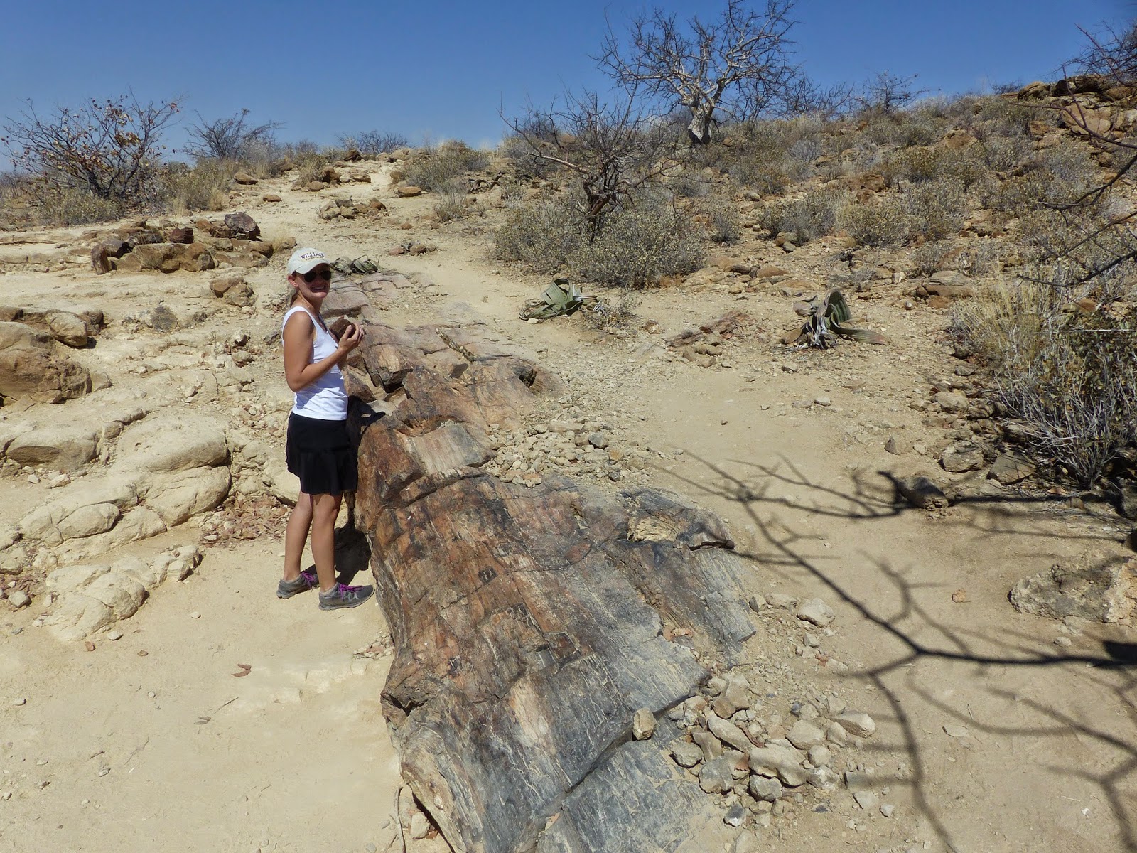
The Twyfelfontein area is also home to an extensive petrified forest.  We backtracked slightly to see the 260 million year old tree trunks emerging from the desert sands.  Giorgio was not quite sure what precisely constituted a petrified forest prior to our arrival, but was fascinated by the way that pressure had transformed the carbon in the massive tree trunks into stone.  Once again, we had a private tour from a local guide and he was somewhat disappointed that we hadn’t seen the similar forest in Arizona.  We will have to make a stop in February!


Sadly, although one of our guidebooks indicated that there was a not-to-be-missed attraction called the “wondergat,” we never found the turn off to this place of wonder, apparently a massive sinkhole in the desert.


After our educational sightseeing, we continued north, deeper into Damaraland.  We had read that even though this area isn’t a national park, there are more wild animals roaming.  Seeing signs for elephant crossing, we were on the look out for the area’s special desert-adapted elephants, but to no avail.  However, a group of giraffes was eager to make our acquaintance!


#stephandgio